
ProPILOT 2.0 (with Google built-in)
Driver assistance technology, combining navigated highway driving with hands-off single-lane driving capabilities
ProPILOT 2.0 is an advanced driver-assistance technology that helps make highway journeys safer and more comfortable.
During single-lane highway driving under specific conditions, hands-free driving can be enabled*1. When the driver activates the system, it can support by controlling the accelerator, brakes, and steering wheel to maintain the flow of travel and keep the car centered in the lane. If there is a slow-moving vehicle ahead, the system suggests a lane change to pass the vehicle and assists the driver with lane-changing.
By using 3D high-definition map data combined with high-precision satellite positioning technology, the system is able to provide a high level of support, even in complicated road environments. This elevates the driving experience and enhances driver confidence and peace of mind.
- Hands-off driving is possible when driving in a single lane, on the condition that the driver remains attentive on the road ahead and is prepared to immediately take manual control of the steering wheel when conditions of the road, traffic and vehicle require it.
How the technology works
The driver can start navigated highway*2 driving by operating a switch on the steering wheel. Once activated, the system will help the vehicle stay centered in the lane and maintain a consistent following distance from the preceding vehicle. Both speed and the following distance is set by the driver.
Hands-off driving is possible when driving in a single lane and the driver's attention is on the road ahead and is prepared to take manual control of the steering wheel when conditions of the road, traffic and vehicle require it.*3
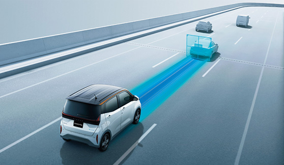
If the preceding vehicle is driving slower than the speed set by the driver, the system will scan for an opportunity to pass and suggest a lane change to the driver with audio and visual guidance. The driver can confirm the pass by placing both hands on the steering wheel and operating a switch. Upon the driver's confirmation, the vehicle will smoothly move into the passing lane. Once the slower vehicle has been passed, the system will scan for an opportunity to return to the driving lane. Once the return lane is clear, the system will suggest returning to the lane and support the lane change after the driver confirms.
Similarly, if the driver wishes to change lanes, the driver places both hands on the steering wheel and activates the turn signal. The vehicle will change lanes once the system has determined that a lane change is possible.
- A national expressway as prescribed by the National Expressway Act. A limited highway as prescribed by the Road Act.
- The hands-off feature is not available in tunnels where a GPS signal cannot be established, on expressways that have two-way traffic, on winding roads, in tollgate areas or merging lanes. When entering a road section where hands-off driving is not available, the system will alert in advance so the driver can take manual take control of steering.
Technology configuration
Hands-off highway driving uses 3D high-definition map data, high-precision satellite positioning technology, 360-degree sensing and intelligent interface.
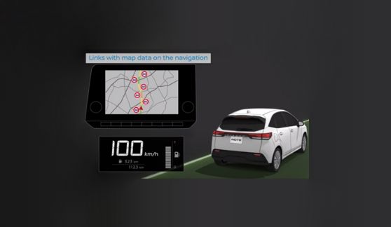
1. 3D high-definition map data
Map data used consists of highway road structure information at a centimeter level and includes road curvature, slope, lane marking information, speed limit data and signage. By utilizing detailed road information to anticipate conditions ahead, the system offers an elevated level of safety and a smoother driving experience.

2. High-precision satellite positioning technology
When referring to 3D high-definition map data, the system uses information measured by the Global Navigation Satellite Systems (GNSS)*4 to pinpoint the vehicle's position on the highway. Under typical conditions, positioning data from GNSS has a margin of error of 10-15 meters. By using high-precision positioning technology, the ProPILOT 2.0 system is able to identify the vehicle's lane accurately at the centimeter level.

- Global Navigation Satellite System (GNSS) is the global positioning satellite system, mainly represented by GPS.
- Code Positioning is a positioning method using information transmitted by radio waves from satellites.
- Carrier Phase Positioning is a method of increasing accuracy by analyzing the actual radio waves transmitted by satellites.
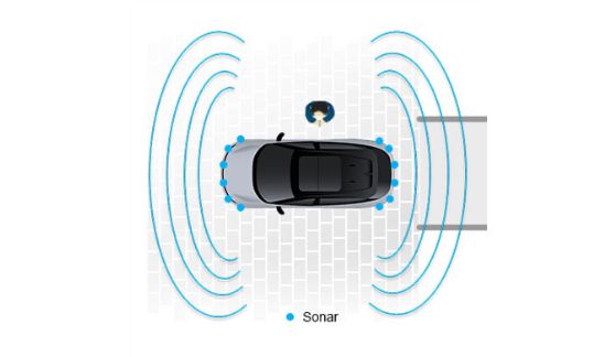
3. 360-degree sensing
The system uses 5 cameras, 5 radar sensors and 12 sonar sensors to detect lane markers, signs and surrounding vehicles.


Sensing data in the system
4. Intelligent interface
The system assesses the road, surrounding conditions and system control in real time to determine suitable lane change timing.

- Google is a trademark of Google LLC.
Related Technology

ProPILOT
Significantly reduces driver stress when driving on highways in several kinds of traffic conditions, making long drives more comfortable and enjoyable